Kingdoms of Ancient and Medieval West Africa & Trade across the Sahara
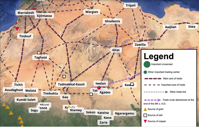
The Gold Road ProjectThe Gold Road Interactive Map highlights the people, places, and items related to the medieval Sudanic empires of Ghana, Mali and Songhai. Gold, the region’s most valuable resource, moved along regional and trans-Saharan routes reaching as far north as France.
|
Lessons
|
Tools to Teach about Three Medieval West African Kingdoms
- Ghana, Mali and Songhai: Enduring Understandings
- Trade across the Sahara (ThoughtCo article)
- Ancient West African Manuscripts of Timbuktu: An Introduction (Library of Congress site)
- West African Kingdoms (BBC – The Story of Africa)
- Documentary: History of Africa – The Spread of Islam (episode 9) with Zeineb Badawi (BBC)
- Documentary: History of Africa – Desert Empires (episode 10) with Zeineb Badawi (BBC)
- Documentary: Caravans of Gold, episode 3, with Basil Davidson.
Specific Kingdoms
Ghâna
- Kingdom of Ghâna Primary Source Documents
- Kingdom of Ghana Audio File (BBC Story of Africa Series, 28 min)
Mali:
- Kingdom of Mali Primary Source Documents
- Caravans of Gold, Fragments in Time (companion website to the Block Museum exhibit)
- Podcast: Medieval Africa at the Aga Khan Museum in Toronto: a 22 minute podcast on the Caravans of Gold exhibit of the Block Museum, currently in Toronto.
- Sundiata: An Epic
- The Road to Timbuktu (PBS)
- Lesson Plans: Trekking to Timbuktu (Edsitement-NEH site)
- The Travels of Ibn Battuta: A Virtual Tour: this website from the Office of Resources and International Affairs (ORIAS) at UC Berkeley provides a comprehensive resource to the famed traveler’s itenerary and present images, a map, student activities, a chronology, and a bibliography.
- Mansa Musa Lesson Plan (SHEG)
- Mansa Musa and Islam in Africa (Crash Course World History episode that also addresses East Africa)
Songhai:
- Kingdom of Songhay Primary Source Documents
- Great Empires of Mali and Songhai Audio File (BBC Story of Africa Series, 28 min)
Bibliographies and Other Resources
![africankingdoms_clip_image001[1]](/africa/files/2013/10/africankingdoms_clip_image0011.gif "africankingdoms_clip_image001[1]")