Ahead of the United States’ 250th anniversary on July 4, we asked our community members to name their favorite Greater Boston Revolution-era landmark — and explain why it matters to them.
Daniel M. Abramson, professor, architectural history, and director, architectural studies: Lexington Battle Green obelisk
 In a corner of Lexington’s Battle Green raised on a small mound is a plain gray granite obelisk. It was erected in 1799 to memorialize the eight men killed on the Green in the skirmish that launched the American Revolution twenty-four years earlier. I pass the monument most mornings walking my dog.
When I happen to glance at it I’m always amazed by the object’s earnestness and outrage. Its very lengthy inscription, cut deeply into the stone, commences: “Sacred to Liberty & the Rights of mankind!!!” It continues — “The Die was cast!!!” and “They nobly dar’d to be free!!!”—before ending some two hundred words later.
Revolutionary Lexingtonians certainly loved their exclamation points!!! And I appreciate their ardor and loquaciousness. They clearly believed in the power of the written word for which the austere monument serves as eternal substrate.

Mary Battenfeld, clinical professor of American studies: Old South Meeting House
 Boston holds so many historic spots, including the North American Indian Center of Boston, which on June 22 was honored with landmark designation as part of the “Everyone 250” historical marker program. But if forced to choose just one, I would say the Old South Meeting House.
For 300 plus years, the Old South has been the site of public protest and democratic debate, from the well-known Boston Tea Party, to the 1836 eulogy to Metacom (King Philip) by William Apess to contemporary actions, such as one in December 2025 to dump ice in Boston Harbor as a protest against federal immigration policies. Old South is also a beautiful building, saved from destruction in 1876 by a group of women, using the same tools, as The New England Historical Society says, “that had made it historic: rhetoric, organization, patriotism and civic action.”
As a faculty member in a program with a well-deserved national reputation for research in historic preservation, and interdisciplinary teaching of American history, I also chose the Old South Meeting House because of its importance in bringing American history alive for generations of students. Old South is not just a historic spot, but a living democratic space, reminding me, as Joseph Warren said in his March 6, 1775, Old South Boston Massacre oration, that “our country is in danger but not to be despaired of.”

Japonica Brown-Saracino, chair and professor of sociology: The North End

It is nearly impossible to choose a single, favorite historic place in Boston. In fact, it is so challenging that I must name an entire neighborhood. The North End is my favorite historic place in Boston because it contains so much history in such an evident way. Of course, the North End is home to high-profile Revolutionary historic landmarks, including Paul Revere’s house and the Old North Church.
When I take students from my Boston’s People and Neighborhoods course to the North End, we note those important landmarks, but I also call them to look for evidence of how the North End has housed so many different social groups – many of them immigrant groups – since the Revolution. We visit Old North Church, but we also look for the Star of David off Salem Street, evidence of the neighborhood’s Jewish population in the late 1800s and early 1900s. I tell them about periods in the 1800s when English, German, and Irish immigrants lived in the North End, and we visit Copps Hill Burying Ground where many Black Bostonians were laid to rest. Of course, we can’t miss the presence of Italians in the neighborhood (we often stop for pizza at Galleria Umberto’s), but I ask my students to recognize how, in a relatively short period of time, many different immigrant groups called the neighborhood home.
The North End is an excellent example of the “neighborhood succession” that Robert Park and other members of the Chicago School of Urban Sociology identified as a central fact of urban life, whereby one social group comes to replace another in a neighborhood. This, Park and his colleagues argued, drives the push and pull characteristic of urban life. But the North End doesn’t just illustrate sociological concepts. There are so many layers of Boston’s history and of our nation’s history in the North End and those layers are on ready display for any careful observer. Looking forward from the Revolution, over the course of just a few centuries one very small neighborhood has held so many.

James Feigenbaum, professor of economics: Boston shoreline
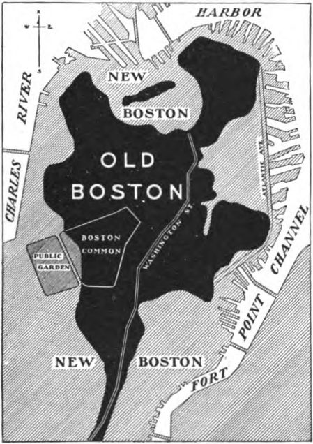
 Not exactly revolutionary and not exactly a place… but I’m kind of obsessed with all the land reclamation Boston did to grow its land area. The Boston Public Library has a bunch of maps about the changes over time in Boston’s shoreline and size. I know there are several places across the city where maps like these are up on public displays. I always have to stop and study them. There is also a permanent exhibit at Fanueil Hall.
But closer to the campus—actually on campus, on Bay State Road—the original banks of the Charles River are traced in the sidewalk. I took my kids to my office a few weekends ago—as one does when you’re a really cool parent—and my 6-year-old was stunned looking at where the Charles is now and thinking about how the seemingly solid land we were standing on used to be part of the river.
The economics of land reclamation are also really interesting. The demand for space to live and work in Boston was so high—and the technology for vertical density wasn’t so well developed in the 19th century—that the people of Boston literally created new land, filling in the water on all sides and enlarging what had been the tiny Shawmut Peninsula.
Aaron Garrett, professor of philosophy: Corner of State Street and Kilby Street
 What is now the corner of State Street and Kilby Street was in the mid-seventeenth century the corner of King and Mackerel. Today there are anonymous granite buildings at the corner and a branch of Banco Santander. It was the home of the Wheatley family and of Phillis Wheatley Peters, one of the greatest of all American poets who was enslaved in their household. There is as far as I know no plaque or reminder. After the 1773 publication of her Poems on Various Subjects, Religious and Moral she became celebrated in America and England while still enslaved. When she visited London in 1773, the Secretary of State for the Colonies gave her an audience. He likely did not believe a young enslaved woman was capable of writing such extraordinary poetry. She wrote “To the Right Honorable William, Earl of Dartmouth” shortly after. This passage better captures the paradoxes of the American founding than any work I know.
Should you, my lord, while you peruse my song,
Wonder from whence my love of Freedom sprung,
Whence flow these wishes for the common good,
By feeling hearts alone best understood,
I, young in life, by seeming cruel fate
Was snatch’d from Afric’s fancy’d happy seat:
What pangs excruciating must molest,
What sorrows labour in my parent’s breast?
Steel’d was that soul and by no misery mov’d
That from a father seiz’d his babe belov’d:
Such, such my case. And can I then but pray
Others may never feel tyrannic sway?
Wheatley Peters looked at the world from this spot in the heart of Boston as the revolution progressed. It is worth standing here and meditating on who looked at the events of the revolution from what vantage. And also meditating on which places are preserved to celebrate the colonial period and American Revolution and the places which were buried, built over, and forgotten.

Reed Gochberg, Ph.D. (GRS‘11, GRS‘16), Curator, Boston Athenaeum: Boston Common
 I can’t walk across the Common without picturing Christian Remick’s “Prospective View of the Commons,” a 1768 watercolor featuring vignettes of individual figures and groupings, showing women headed to a social call, accompanied by an enslaved man; the 29th regiment drilling near their tents, while children (and dogs!) look on; or groups of laborers, white and Black. This image highlights the many people living in close proximity to each other and going about their everyday lives in the midst of major political events, and it reminds us of the connections between various social, cultural, and political activities taking place at the same time. Much like today, the Common was a place where people crossed paths and shared public space, and it has a tremendously rich and multilayered history.

Daryl Healea, Ed.D. (STH’01, Wheelock’11), assistant dean for curriculum & enrollment services: Long Wharf
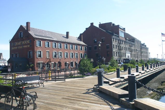
 My favorite place is Long Wharf, which was constructed in the early 1700s and extended much further into Boston Harbor than it does today. It was a critical component of Boston’s shipping economy throughout the 18th century. Moreover, Boston University’s founder and benefactor, Isaac Rich, who was a fishing industry tycoon in the 19th century, got his start selling fish and oysters in nearby markets.
The adjacent Boston Custom House (also 19th century) towers over the wharf and makes for an impressive site even to this day. When I first moved to Boston in the late 1990s, my former colleagues and I in BU Residence Life would take hundreds of BU students to Thompson Island from Long Wharf each August and we had a fantastic time. Ever since, I’ve taken family and friends there to stroll along the harbor whenever I have the chance. It’s a historic treasure for Boston.
Loretta Lees, professor of sociology and director of the Initiative on Cities: Beacon Hill
 As a Brit who moved to New England to one of the US’s most English cities nearly five years ago now, I am reminded daily about the US’s independence from the British Empire as I own a dish towel that I bought in Faneuil Hall that says “Too cool for British Rule.”
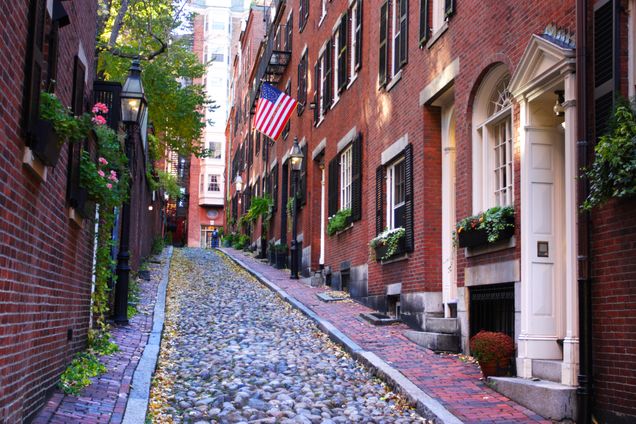
When I have visitors from overseas I often take them to Beacon Hill, one of my favorite historical places in Boston because it retains some of the oldest homes in the city—classic red brick houses, Colonial, Federal and Greek revival styles, cobbled streets and old gas street lights. The first European settler, a fellow Brit, built a house there in 1625. Beacon Hill gets its name from a tall wooden beacon erected in 1635 at its highest peak to alert of impending danger or enemy attacks. In 1775, to fortify Boston during the Siege, a British General ordered the removal of the beacon and built a small fort in its place. When the British were evacuated in 1776, Bostonians quickly replaced it.
Beacon Hill used to be the highest point in central Boston – as urban geographers like myself know too well urban elites always territorialize the highest points in cities. Boston’s Brahmins (often descendants of the original English colonists), the city’s wealthy and powerful, built homes on the southern slope of Beacon Hill looking over Boston Common. In 1807-1832 Beacon Hill was reduced from 138 feet to 80 feet and the fill used to extend the footprint of Boston’s landmass. The northern and western slopes of Beacon Hill became home to the working and middle classes, including many free African Americans, and became a hotbed of abolitionist and Underground Railroad activity in the run up to the US Civil War.
As an urbanist I love to walk through this original old streetscape designed before cars were even invented. The narrow roads make it a truly ‘walkable city’ environment. I love the beautiful doors, the stoops, the window boxes and ornate iron railings. As someone who has researched gentrification and how elites make and remake cities for the past 30 years I must point out that this is one of the most expensive and desirable neighborhoods in Boston. I did look to buy a house there but thought the $8 million to $20 million price tags too much!
Brendan McConville, professor of history: Westerly Burying Ground
 My favorite historical spot is a small graveyard on Centre Street in the West Roxbury section of Boston, near my home. It contains the graves of a few young colonial soldiers who died during the siege of Boston in 1775, probably of what were called camp fevers, the epidemic diseases which often swept through armies in the Early Modern period. They died defending New England from what they understood to be the efforts of the British government to establish tyrannical government in the British colonies. I also like the Copp’s Hill Burial Ground in the North End, it holds the remains of a number of key figures from colonial and revolutionary Boston, and was the site of a British artillery battery that was involved in the Battle of Bunker Hill.
Finally, I like the statue of Doctor Joseph Warren on the campus of the Roxbury Latin School, also in West Roxbury, he died at Bunker Hill, fighting as a private in the front lines, even though he was a leader of the provisional government of Massachusetts at the time, in June 1775, had already been voted the rank of general, and could have avoided combat had he chosen.

Anita Patterson, professor of English: Boston Common

My favorite historical spot in Boston is the Boston Common, where the American Transcendentalist philosopher and poet Ralph Waldo Emerson had a transformative encounter with the natural world that was featured in Nature (1836), one of his best-known books. Suddenly realizing the absolute unity of man and nature, Emerson famously described this experience as becoming a transparent eyeball standing on the bare ground, writing, “I am nothing, I see all; the currents of Universal Being circulate through me.” Emerson’s contemporary, the poet and artist Christopher Cranch, drew a memorable caricature of this image that was widely circulated and is now held in the Metropolitan Museum of Art.

Cady Steinberg (CAS’12, Wheelock’18), administrative manager, history and African American & Black Diaspora Studies: Washington Park, Chelsea
 My family has two very different immigrant experiences, my dad’s family fled from pogroms in the early 20th century, and my mom’s family is descended from Pilgrims on the Mayflower. It’s always been an interesting dichotomy for us to explore as a family. Her side eventually settled in Chelsea, founding what became “Prattville,” where the park is located. So having this close connection to the Revolutionary activities and Colonial America is fascinating.

Carolyn White, professor, history of art & architecture and archaeology, and director of preservation studies: City Square Park, Charlestown
 One of my favorite places in Boston is City Square Park in Charlestown. This little urban park is the location of an important site in American history. In 1630, Governor Winthrop built a “Great House” on this land, but lived there only temporarily. His house became a meetinghouse, and then a tavern, called the Three Cranes Tavern, a popular gathering place for Charlestown residents from 1629 to 1775. It was burned to the ground during the Battle of Bunker Hill, but archaeological excavations in the 1980s uncovered the building’s foundations and extensive evidence of its use. Wine bottles, dishes for serving and consuming food, and food remains were recovered, as were pieces of clothing, gaming pieces, and clay pipes—evidence of daily activities of Charlestown’s earliest inhabitants. The footprint of the building is preserved as part of the park today—a secret history preserved in plain sight.

Merry (“Corky”) White, professor emerita of anthropology: Copps’ Hill Burying Ground
 Without deep thought on this, I come up with Copps’ Hill Burying Ground in the North End. It’s in a beautiful location, just a short walk uphill from Salem Street, one of my favorite streets where I can show my students the variety of people in layers of immigration to the North End. It is only the relatively recent migrations of Italians who eventually gave it its recent ‘Italian” identity — they weren’t even “Italian” when they came as the country had only recently unified — and they called themselves Abbruzzese, Siciliano, Pugliese, etc, paesani of regions, not a nation. Salem Street also has remnants of the Jewish layer of the North End, with some old signage of Hebrew schools and shuls.
Copps’ Hill has everyone. Established in 1659, it holds the remains of revolutionaries and colonials, blacks and early artisans and business people. There is, in the northwest quadrant, a section where blacks were buried, including Prince Hall, a black revolutionary soldier, and founder of an early black organization. Just to stand among the old stones and look out to the water is a wonderful experience. And then, walk back down to Hanover Street and get yourself a good espresso macchiato and an apricot-stuffed cornetto at Cafe Paradiso.

Interested in sharing your favorite historical spot? Email us.