The Climate Crisis: Measuring Boston’s Metabolism
CAS researchers track the city's carbon digestion
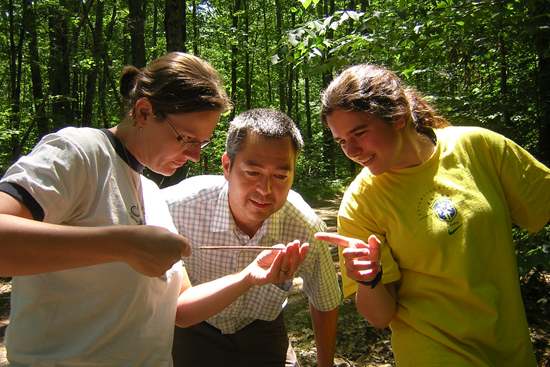
In the video above, Lucy Hutyra, a CAS assistant professor, and Nathan Phillips, a CAS professor, discuss how their Boston ULTRA-Ex (Urban Long-Term Research Area Exploratory) project tracks the city’s carbon digestion.
In this weeklong series, BU researchers explore the science behind Earth’s environmental changes, and what they mean for our future.
Imagine looking at Boston and its people as one living, breathing organism. The city consumes energy in the form of resources and services, processes them into gross domestic product, and produces waste. Some of that waste, the carbon dioxide spewed from industrial smokestacks, vehicle exhaust systems, buildings, and even people, contributes to global warming.
Now imagine tracing that carbon through space and time. That’s what Lucy Hutyra, Nathan Phillips, and a team of researchers plan to do, in an effort to understand the origin of Boston’s carbon emissions, how carbon is stored, and what the net balance of these activities means for the future of the city—and the planet.
Carbon is “like the life blood that’s flowing through the system,” says Phillips, a College of Arts & Sciences professor of earth and environment. “Understanding cities and their overall carbon emissions is absolutely crucial to understanding the global carbon cycle and global climate change.”
“If we are going to have a prayer of actually reducing greenhouse gas emissions, meeting commitments, and creating these international treaties,” says Hutyra, a CAS assistant professor of earth and environment, “we need to know where carbon dioxide is coming from within cities.”

Hutyra says nearly 70 percent of global carbon dioxide emissions come from cities, which cover only 3 percent of the Earth’s surface but are home to more than half of the world population. That would seem to make cities the obvious place for ecologists to study global warming, but until recently, few scientists were studying urban areas as unique ecosystems.
In 2009, the National Science Foundation and the U.S. Forest Service announced a two-year grant that would support research in what they call an Urban Long-Term Research Area (ULTRA). Hutyra and Phillips applied as co–principal investigators and were among a select group of scientists who landed a $300,000 exploratory grant for Boston. Their project, aptly called the ULTRA-Ex: Metabolism of Boston, has since expanded to include more than 50 scientists from BU, Harvard, MIT, Northeastern, and UMass. Funders now include NSF, NASA, the Environmental Defense Fund, and IBM Smarter Cities.
ULTRA collaborators measure such things as carbon emissions, carbon storage, land cover change, and how growing seasons are extended by urban heat islands—metropolitan areas that are warmer than their surroundings because of human activities—all of which should yield a picture of how the city consumes, digests, and spits out carbon. While conclusions are still far away, the team has already had a variety of aha moments.
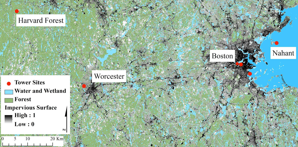
One of the first involves Phillips’ measurement of atmospheric carbon. He and other researchers established six observation towers in and around Boston—at BU, the Prudential building, UMass-Boston, Nahant, Worcester, and the Harvard Forest in Petersham, Mass.—and rigged each with a Picarro instrument, which records carbon dioxide levels multiple times a day.

ULTRA researchers gather atmospheric carbon dioxide readings from six sites in and around Boston. Image courtesy of Hutyra
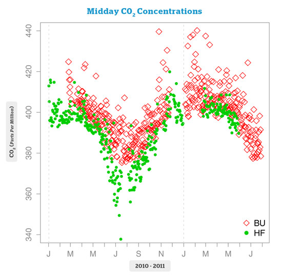
Phillips found that the levels reflect human activity and the seasons, registering higher during rush hour traffic and peak winter heating months and lower during weekends and summer vacation times. Not surprisingly, readings in rural sites like Harvard Forest are consistently lower than those at urban sites like BU. “We’re coupled in this kind of dance with carbon,” he says. “What becomes clear is that you can’t think of the human side of emissions and the natural systems in isolation from each other.”
Atmospheric carbon levels can easily be measured, but their sources are harder to identify. The U.S. Environmental Protection Agency reports that nearly 30 percent of carbon dioxide emissions come from vehicles. Yet Hutyra says there is no reliable method for accurately pinpointing these emissions over space and time—information that’s crucial if governments hope to monitor and control emissions at the level of cities, states, or nations over confined periods. As noted in a paper written by one of Hutyra’s graduate students, Conor Gately (GRS’14), and published in January in Environmental Science & Technology, accepted models used to estimate emissions vary by up to 30 percent.
“Understanding cities and their overall carbon emissions is absolutely crucial to understanding the global carbon cycle and global climate change.”
Gately wanted a better model. As the project manager of the IBM Smarter Cities challenge in Boston, he worked with IBM engineers and city officials from the Department of Innovation and Technology (DoIT) to funnel the city’s existing traffic and congestion data through a public website, to be unveiled this summer. He hopes the new database will spark innovation, inform public policy, and support research that improves emissions estimates—and soon, given that Boston Mayor Thomas Menino (Hon.’01) has set a goal of reducing the city’s total greenhouse gas emissions by 25 percent by 2020.
Hutyra’s contribution to ULTRA overlaps with her study, funded by an NSF CAREER Award, of how differently plants behave in urban and rural environments. Boston is a relatively green city, with about 28 percent canopy cover, she says. That’s important in terms of global warming because trees remove carbon dioxide from the air through photosynthesis and provide shade, which reduces the urban heat island effect and air conditioning’s energy demand.

Since 2010, Hutyra, postdoctoral associate Steve Raciti, and graduate assistants have gone into the urban forest (which could mean two elms along the side of a building) to measure tree circumferences and take soil samples to determine their chemical composition. They published their findings last year in the journal Ecological Applications, writing that carbon concentrations in urban vegetation and soil were higher in a city’s forested regions than in residential and other developed land areas. Hutyra thinks urban trees are adapting—and possibly growing faster—in this carbon dioxide–rich environment.
Soil covered by pavement or concrete doesn’t fare as well. Raciti, Hutyra, and Adrien Finzi, a CAS professor of biology, wrote last year in Environmental Pollution that soil under impervious surfaces in New York City contained 66 percent less carbon and 95 percent less nitrogen than that found in exposed soil. Perhaps most disturbing, says Hutyra, is that “we don’t know where it went. The soil was also for many purposes dead. There was no microbial activity remaining.”
Knowing how much carbon is stored in trees and the soil will help determine the amount released into the atmosphere through land development or deforestation. That’s where remote sensing, the science of obtaining information about objects or areas from a distance, typically from aircraft or satellites, comes in handy. ULTRA collaborators Mark Friedl, a CAS professor of earth and environment, and Curtis Woodcock, a CAS professor and chair of earth and environment, are using satellite imagery to reconstruct how land cover has changed around Boston since the 1980s. Development alters the Earth’s surface so that pavement, sidewalks, and buildings replace existing vegetation. Satellite imagery reflects such changes, and once stitched together, can provide a time-lapse map of Boston and the metropolitan area.
Deforestation results in “a net release of carbon to the atmosphere,” Friedl says. “Depending on the age and size of trees in a forest, it could be substantial.” The reverse is true as forests flourish in previously developed spaces.
Friedl also uses remote sensing to track seasonal change. As spring arrives earlier and fall later, plants have a longer growing season and absorb more carbon dioxide. This change is visible through satellite imagery, which Friedl double-checks through a system of cameras that take daily pictures of places like Storrow Drive and Boston Common. In 2010, he was stunned to see how big an effect the urban heat island, and resulting longer growing season, had on city trees. Those in Boston Common leafed out nearly three weeks before those in Harvard Forest—just 70 miles west.
BU’s ULTRA research is complex and diverse, but “if you put this all together, you can start to get the metabolism” of Boston, says Hutyra.
“This would be an ivory tower exercise,” Phillips says, “if it didn’t have an applied goal. And that applied goal is to increase sustainability in Boston and in other cities as well.”
This Series
Also in
The Climate Crisis
-
March 25, 2013
The Climate Crisis: Why the Earth Is Warming
-
March 26, 2013
The Climate Crisis: Tracking Change, Predicting Trouble
-
March 29, 2013
The Climate Crisis: Your Job or Your Planet?

Comments & Discussion
Boston University moderates comments to facilitate an informed, substantive, civil conversation. Abusive, profane, self-promotional, misleading, incoherent or off-topic comments will be rejected. Moderators are staffed during regular business hours (EST) and can only accept comments written in English. Statistics or facts must include a citation or a link to the citation.