Great Places for Hiking in and around Boston
Easy access to treks from less than a mile to three hours long
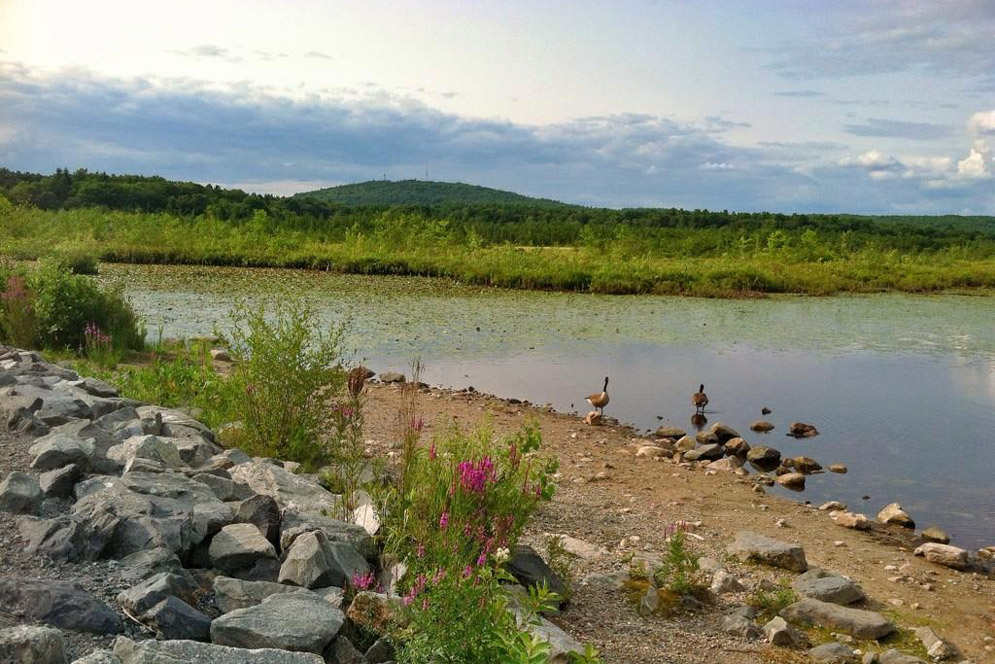
Visitors to Blue Hills Reservation, with 125 miles of trails spread over 22 hills, from Quincy to Dedham and Milton to Randolph, can take their pick of hikes, from less than a mile to three hours long. Photo by Brian MacLean
Great Places for Hiking in and around Boston
Easy access to treks from less than a mile to three hours long
With a population of more than 689,000, Boston is New England’s largest city, and factoring in the 4.9 million people who reside in the greater metropolitan area, it can often feel congested. Fortunately, the area has over 2,000 acres of open space, much of it accessible by public transportation. We’ve put together info on 10 areas that provide great opportunities for both novice and experienced hikers.
Have a favorite hiking destination not listed here? Add it in our Comment section below.
Emerald Necklace
The Emerald Necklace, a series of interconnected parks comprising more than 1,000 acres, stretches over seven miles, from the Back Bay to Dorchester, and offers an array of activities close to home. It was designed over almost 20 years (1878-1896) by landscaper and urban planner Frederick Law Olmsted, who designed New York’s Central Park, among many other sites. Each park within the Emerald Necklace is a unique experience. Below are six Emerald Necklace areas offering good opportunities for hiking.
Back Bay Fens has several interesting features: the formal Kelleher Rose Garden, the Fenway Victory Gardens, originally planted in 1941 to help in the war effort, the World War II, Korean War, and Vietnam Memorial, and the Shattuck Visitor Center, home of the Emerald Necklace Conservancy. It also has a 17th-century Japanese Temple Bell, ample paths for walking and running, and ball fields, basketball courts, and a running track for the athletically inclined.
Between Boston and Brookline, the Riverway boasts 34 acres of hiking and bicycle paths that meander along recently restored sections of the Muddy River. With its over 100,000 plantings, the park also has many picturesque stone bridges.
If you prefer ponds and meadows, Olmsted Park has both: there are hiking, biking, and walking trails and three separate ponds, along with a wildflower meadow.
Jamaica Pond, with a 1.5-mile path for jogging and hiking, is the largest standing body of fresh water in the city. The glacial kettle pond also has facilities for sailing, kayaking, and rowing, and those with a permit can fish in the pond. The Pinebank Promontory, adjacent to the pond, is the site of Summer Sundays in the Park outdoor concerts and movies and is a prime spot for picnics.
Take more of a walking tour than a hike at Harvard’s 281-acre Arnold Arboretum, one of the world’s finest botanical collections, with approximately 4,000 shrubs, trees, and vines—more than 15,000 plants in all. There are self-guided tours with themes such as “Centenarians,” trees that are over a century old, and guided tours led by docents. At the Hunnewell Visitor Center, visitors can ask questions, view the arboretum library’s historical archives, take in seasonal art exhibitions, and find information about activities for all ages. Picnicking is prohibited, but the visitor center can provide park-goers with maps of local eateries. Find an interactive map here showing current plant highlights along the park’s trails so you can plan a self-guided tour.
Finally, Franklin Park, named for Benjamin Franklin, is the largest park in the Emerald Necklace, at 527 acres, and has 6 miles of roads and 15 miles of pedestrian and bridle paths, offering some of the best walking trails in Boston. It is home to the renowned Franklin Park Zoo, as well as athletic fields, an 18-hole golf course, Schoolmaster Hill, with its spectacular view of the Blue Hills, and the Wilderness, a popular and historic hiking area.
Harvard’s Arnold Arboretum, part of the Emerald Necklace park system created by Frederick Law Olmsted, has 281 acres and more than 4,000 kinds of trees, shrubs, and vines. Photo by Plant Image Library/Flickr
A series of free Parks as Platform events are available to the public April through October 2022. The series involves the Emerald Park Conservancy collaborating with the six Emerald Park areas for programming and extra support, such as securing permits, coordinating volunteers, and providing amenities like signage and portable restrooms. The goal is to increase park access and welcome expanded audiences.
Boston Harbor Islands National and State Park
A short ferry ride from the city, Boston Harbor Islands National and State Park offers seasonal camping sites on four of the islands (Bumpkin, Grape, Lovells, and Peddocks).
If sleeping in a tent isn’t your style, the islands still provide many ways to enjoy nature without having to get out of town. Visitors can search for wildlife, relax on the beach, and learn the history of the park’s 34 unique islands and peninsulas, 7 of them accessible by ferry. Little Brewster Island, the home of Boston Light, is the oldest continually used light station in the country (it dates to 1716).
There is Georges Island, with historic Fort Warren and sweeping views of the other islands from its towers. Spectacle Island, just a 30-minute ferry ride from Long Wharf North, has beaches and the tallest hill on the islands, while Peddocks Island has historic structures, cottages that still house residents, and hiking trails. Lovells Island has six small campsites that accommodate up to 6 people each and two group campsites that can host up to 50. You can go swimming and hike along the island’s rocky coast and explore the remnants of Fort Standish. Rounding out the islands are Grape Island, known for its wildlife and wooded trails and great for hiking, kayaking, and picnicking; Bumpkin Island, which, along with flower-lined trails and slate beaches, houses several campsites and the remains of a children’s hospital; and Thompson Island, which has salt marshes, beaches, and a conference center—and hosts numerous summer youth programs.
If you’re hungry, make sure you fuel up at Georges or Spectacle before making your way to the others, as they are the only two with snack bars. Ferries are stocked with snacks and drinks.
Neponset River Greenway
This asphalt biking and pedestrian trail stretches approximately five miles from Dorchester to Mattapan and Milton and allows for biking, walking, and running. The trail is easily accessible by MBTA. Recent extensions to the Neponset River Greenway have been added, including a one-mile stretch connecting Pope John Paul II Park to Mattapan Square, with a canopy walk winding above the Mattapan high-speed trolley path and the Harvest River Bridge connecting the Milton and Mattapan sides of the Neponset River. Plans to expand the greenway to 10 miles, ultimately connecting it to the Blue Hills Reservation, are underway.
Blue Hills Reservation
The largest park within 35 miles of Boston, the Blue Hills Reservation has more than 7,000 acres of green space and 125 miles of trails spread over 22 hills, from Quincy to Dedham and Milton to Randolph. Trails go through upland and bottomland woods, marsh, swamp, and pond edges, and even through an Atlantic white cedar bog. From the top of Great Blue Hill’s 635-foot peak, hikers can view Boston, and on a clear day, even glimpse New Hampshire’s Mount Monadnock, nearly 70 miles away. The Blue Hills Observatory and Science Center, a National Historic Landmark, is well worth a trip to the top.
Hikers can take short jaunts of a mile or less or more strenuous three-hour hikes. You can buy trail maps at the reservation headquarters, 695 Hillside St., or the Trailside Museum, 1904 Canton Ave. Of particular note is the Skyline Loop Blue Blazes, a three-mile hike up to Great Blue Hill. Download a trail map and guide here. Find suggested hikes here.
Each of the above sites is accessible by public transportation. Find directions to the Blue Hills Reservation here, and directions to the Arnold Arboretum and the other Emerald Necklace parks here. Directions to Boston Harbor Islands National and State Park are here, and fee information here. Find directions for the Neponset River Greenway here.
Comments & Discussion
Boston University moderates comments to facilitate an informed, substantive, civil conversation. Abusive, profane, self-promotional, misleading, incoherent or off-topic comments will be rejected. Moderators are staffed during regular business hours (EST) and can only accept comments written in English. Statistics or facts must include a citation or a link to the citation.