 |
|
||
|
Vol. V No. 6 · 21 September 2001 |
|||
B.U. Bridge is published by the Boston University Office of University Relations.
![]()
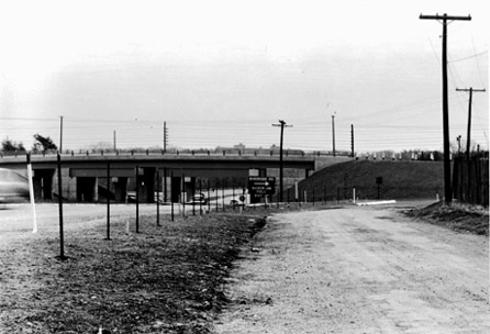
Nickerson Field isn't at the center of the Charles River Campus. Nevertheless, it's considerably closer than it was 50 years ago. For a generation, Nickerson Field was in Weston, Mass., about 10 miles west of its present location, which made home games a relative term. It was the 1951 opening of Route 128 -- critics called it the "highway to nowhere" -- that forced BU to find a home closer to home. As luck would have it, soon the University would be able to purchase Braves Field from the departing National League baseball team, in 1953.
Route 128 was once considered both a public works folly and a concrete boondoggle. "It passed through low-density suburbs," says Yanni Tsipis, a transportation historian and author of Boston's Central Artery. "It didn't connect any major metropolitan areas."
The story of Route 128 begins with former Department of Public Works Commissioner William F. Callahan, who was appointed in 1934. Realizing that Boston was bursting at the seams, he envisioned a "circumferential highway" that would connect the radial roads and spark economic development in outlying towns. Because of the Depression, however, he could do little more than create a patchwork that connected existing roadways.
Republican Governor Leverett Saltonstall ousted Democrat Callahan from the DPW in 1939. The roadway petered out in the woods of Danvers, and plans languished for a decade.
The highway resurfaced when Callahan was reappointed DPW commissioner in 1949. Immediately, work was begun on a new, limited-access 128. To avoid protests from towns objecting to a highway through their heart, Callahan traced a right of way through farms, fields, and wetlands.
Originally planned as a four-lane roadway, 128 was designed to allow room for the extra lanes that he knew would eventually be added.
The first completed section of 128, which arced nearly 23 miles from Wellesley to Lynnfield, opened on August 24, 1951. That day 18,000 cars drove the $20 million limited-access highway. The stretch from Lynnfield to Gloucester was completed two days later; the final link to Braintree opened in 1958.
Route 128 transformed not just commuting in and out of the city, but also a one-time rural landscape. Almost all the towns outside 128 were at one time villages. Today, a stretch of Route 128 south of Route 2 in Lexington averages 180,605 vehicles a day. Next year construction will begin on bridges in Canton, Dedham, and Westwood, the first step in a $100 million project to add two extra lanes to a 13-mile stretch from Randolph to Wellesley.
Photo by BU Photo Services
![]()
21
September 2001
Boston University
Office of University Relations