
Paper presented at the 64th Annual Meeting, Society for American
Archaeology, Chicago, IL, March 27th, 1999
(Symposium: Classic Maya Ideology in the Three rivers Region).
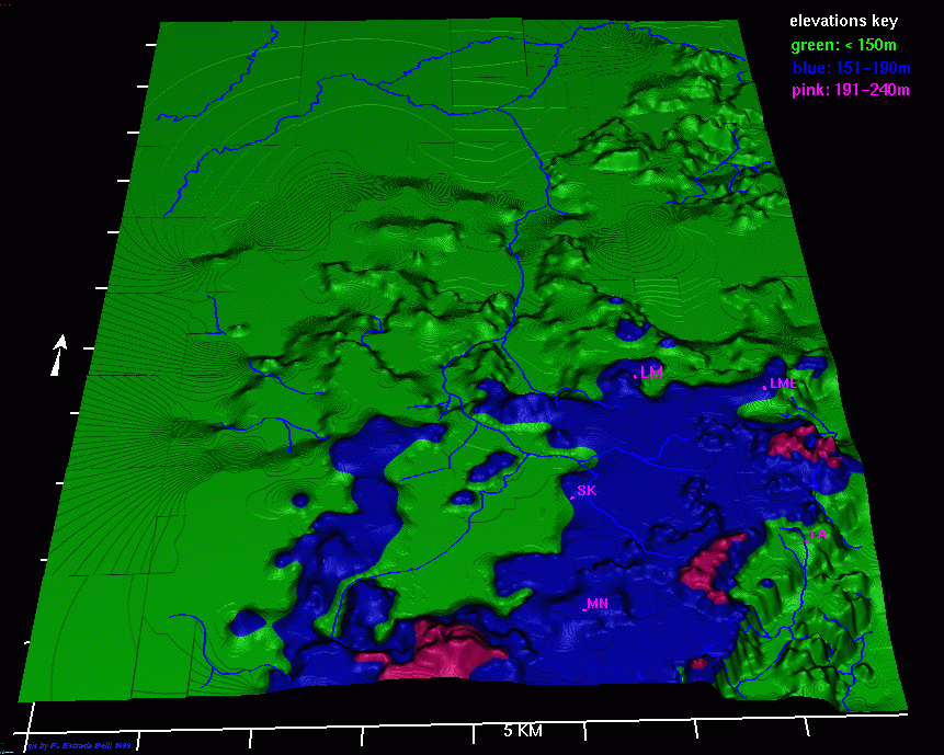
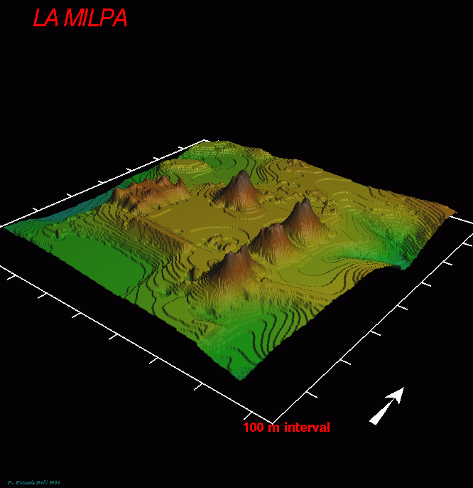
This morning (see also Land and people at La Milpa) you heard about La Milpa (locator map) in its natural landscape: this afternoon we're going to talk about the cultural landscape of the site core. Its location, as we have seen, is a rational one in terms of topography (slide GIS oblique of regional topography), soils and access to various microenvironments, matching other sites in the region. The LF foundation of LM by ~300 BC shows an early recognition of that rationale, but the ridgetop on which the Classic city developed was only one of a number of equal suitability: the Late Classic rulers thus accepted, or even welcomed, the spatial constraints which the landform imposed on the layout of the civic core (sitecore map).
That layout consists in essence of two main groups of structures on
a north-south axis, linked by a sacbe. The northern group consists of Plaza
A, the Great Plaza, at 18Km2 one of the largest public spaces built by
the Maya, the southern of Plazas B and C and their neighboring courts,
together with the Southern Acropolis and its enclosing arc of large courtyard
groups. The only extended history of occupation is below Plaza A (Great
Plaza [3d view
]), where the Late Preclassic village was succeeded by modest public architecture
in the Early Classic, including the 16 of LMs 19 stelae are in the GP,
all but two of those still in situ as well as all but one of those repositioned
in Postclassic times. Plaza
A is thus the focus of collective memory, of sanctity of place and
of royal ancestor veneration. It has four of the five major temple-pyramids
at La Milpa, both ballcourts and the two largest "palace" range structures,
forming the main core of public architecture for community and dynastic
rituals. All of the visible buildings date to after AD 700, as does the
bulk of La Milpa's settlement; this is a pattern common to most sites in
the region. La Milpa was probably abandoned by AD 850, judging by the paucity
of Fine Paste pottery and absence of Postclassic markers, so we have a
minimal palimpsest effect (whereby old and possibly redundant buildings
both affect and complicate the final plan). In fact, looking at the contrast
between the heavily built-up E, S and W sides of the Great Plaza and the
open north, it is possible that the overall concept of the LC rulers was
never completed - a point to which we will return.
Those buildings that are present have varied antecedent histories. Str 1 has a long succession of rebuildings from a Preclassic foundation, although its final two phases at least are Late if not Terminal Classic (i.e. post-800) in date and its flat top suggests that it was left incomplete. Str. 5 has an EC inner substructure dated to Tzakol III by a cache, (Structure 5) encased in the ruler Ukay's modest pyramid of AD 780, dedicated on 9.17.10.0.0. at the same time as Stela 7. Its position in front of Strs. 1 and 2 suggests that it postdates their initial large-scale development, which may be of late Tzakol data. (Great Plazaplan) Structure 8 blocks the axis of Str. 3, itself built over a probably Early Classic precursor, and is associated with a late raising of the plaza floor. Only at this late period can we propose meaningful, rather than cumulatively casual, spatial relationships. Even so, we can plausibly cut the cake in at least two ways - (pairs) opposed pairs of pyramid and palace facing each other across the plaza, Strs. 2 and 9 each having a stela in front (if we accept the butt identified as Stela 18 as such), Strs. 8 and 10 not; (dyads) or dyadic complexes each embracing 2 pyramids, a ballcourt and a palace. In the latter case. all the in situ stelae (except 18) lie within the southern area, suggesting a relationship of hierarchy rather than equality between the dyads. (site core plan).
If we move to the southern part of the site core down the sacbe, we enter an area of contrasting plan - large plazas enclosed by one-story ranges, with one pyramid, Str. 21, apparently abandoned unfinished. The southernmost complex is the acropolis, a bedrock peak on which a north-south sequence of enclosed courts was built. Surrounding it on three sides is an arc of large, widely spaced courtyard groups of the sort we would term elite residences. The plazas are late - Plaza B seems not to have been completed with a level, filled and plastered floor - and the longest architectural sequence, is in the north court of the acropolis, where our 1998 excavations (Op. B70) showed three major phases, all within the period AD700-830, with well built construction including a masonry drain (drain) to the outside. (Acropolis plan) The central court has only one phase and seems to have been added on. On the south side of both courts is a large elevated palace. Str. 38 had been penetrated by a looters' trench which revealed (excavated benches) three successive north-facing plastered benches in a room with a deep red specular hematite floor. (reconstruction) The first was also specular red, with a plain front; the second had an overhanging cornice and relief false legs, and was partly demolished and the third front added, retaining the same top level and matching as best they could the green-blue paint. (Bench C reconstruction) The front was decorated in relief and polychrome, and has the form of a throne. This was also carefully damaged and the room in filled, the doorway blocked and termination rituals carried out, including burning of copal within the room and resinous pinewood outside. (14C date) The latter has yielded an AMS date with calibrated probability peaks at AD 790 and 850. (Acropolis plan) Structure 38 was apparently switched in orientation to face south on to the lower court, where Structure 39 may have taken its place as the seat of power, although no throne remained. Broad stairs and terraces led up to a red-walled chamber which had itself been blocked off, the building again switched in orientation to face south, and a red-painted bench constructed.
This throne, if we may call it such from its impressive axial setting, faced onto the southernmost court of the acropolis, with a newly-constructed set of terraces rising northwards within a boundary bank of rubble over a slabcore. We have clear evidence that this area was never completed: Pl. 123was faced and two small substructures placed at its E end; Pl 131's fill was complete, but it was not faced, while Pl. 130 still lacked part of its fill and the boulder skeleton of the terrace poked out underneath. Areas127, 128 and 129 were still natural hillslope, (Area 127 with boulders) and in the former line of boulders had been laid out to frame the terraces. We can see every stage of the works program in progress: it was a major project of direct concern to the rulership, and its sudden cessation marks the end of La Milpa.
The axial throne rooms of the acropolis suggest successively more grandiose ideas about display of the ruler, but oddly enough the most impressive such attempt was found in one of the neighboring large groups.(Platform 151 Group plan) In the Pl.151 Group, Str. 65 faced north onto a private courtyard. It was a raised C-shaped building enclosing an elevated terrace from which all three wings could be entered separately. (trench Op. C24) An axial trench excavated by Ben Thomas showed a tandem plan central wing, with both rooms floored in specula hematite, the walls surviving to nearly 3m and painted light red, with darker bands emphasizing the wall base and doorjambs. The slightly narrower inner doorway focused attention on a solid bench 4m long, (bench view) originally fitted with raised balusters at each end, which had been carefully demolished when Str. 65 was torn down and infilled with its own masonry and rubble debris. (bench drawing).
The central section of the bench, all that was visible from outside, was ornamented with two false throne legs in relief below the cornice, and with a central pendant trefoil (close-up of painted leg). The entire throne was painted, (throne reconstruction) the top surface in specular red, the cornice in Maya blue, the recessed front in lighter red, and the legs outlined in blue with deep red trefoils. This throne's decorative scheme matches that on the final throne in Str. 38 so closely that they must be close in time. Yet another throne may exist facing east in the inner room of Str. 69. What does all this mean? Dual thrones for a single ruler, that in the acropolis perhaps for the formal seating in power, that in the more commodious residence for everyday use? A sharing of power with Ahau nobles, as suggested for Copan? Or a multipleco-rulership of sibling equals as proposed for Chichen Itza? We don't know.
Finally, I'd like to move out from the tight world of the acropolis
to see how axial organization might function as a wider mechanism of integration.
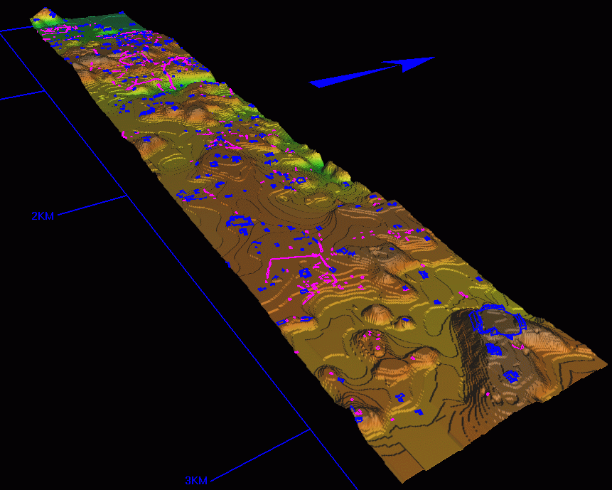
(GIS of
entire site with transects and survey blocks) The evidence here comes from
the east (ET)
and south (ST)
transects mapped by Gair Tourtellot and Marc Wolf, and was stimulated by
Gloria Everson's discovery of the plain Stela 19 in the La Milpa East (LME)
minor center some 3.5 km out from the site core, (Stela19 in situ) as we
discussed at last year's SAA meeting. Stela 19 is in situ and affirm Late/Terminal
Classic date (Stela 19 section). (LME plan) It stands eccentrically, not
axially, in front of the small pyramid, which lies on the east side of
a plaza on which the buildings are, unusually, not cardinally oriented.
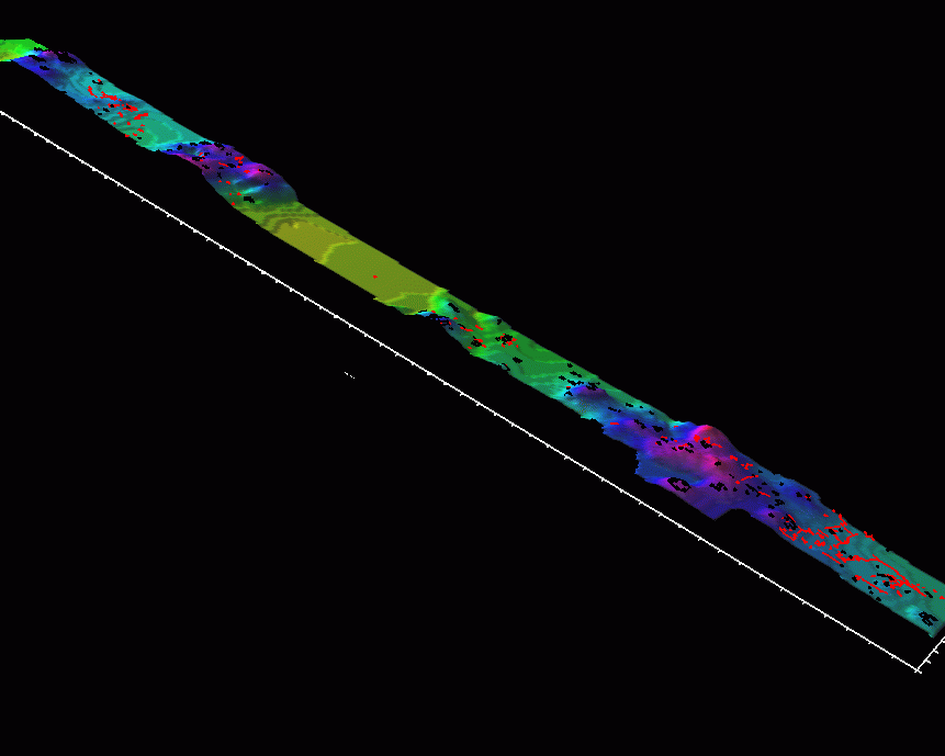
Why? One plausible answer is that intervisibility with the site center,
where the other stelae are located, was desired. (ETViewshed)A
viewshed analysis from the GIS database that Francisco Estrada Belli has
constructed (and which will soon be available to you for consultation on
the Web) shows that the precise positioning of the stela relative to the
open W corner of the plaza allows just such a view. (STViewshed)
On the ST, the slightly small LMS minor center also has a possible plain
stela, and a similar open plan. The viewshed analysis again shows intervisibility
with the top of Str. 1. The use of viewsheds to examine the non-economic
parameters of Maya settlement patterning and community structure may help
to explain why certain features of the built environment take the form
and location that they do, given the alternative choices empirically available
in the landscape. We may be able to see how the Maya combined a practical
exploitation of their environment with conceptual model that imposed a
cosmological unity on the structures of everyday life.
For more info on this GIS dataset email
Francisco Estrada Belli
or go to LAND
AND PEOPLE OF LAMILPA page
or return to B.U. Archaeologypage ![]()
This page created by Francisco
Estrada Belli on 3/31/99
Last modified 5/13/99